The simple solution for companies and contractors
MudShark Earthworks
Mudshark is the leading solution for straight forward cutting edge civil construction software.
Mudshark delivers precise earthwork estimates in record time.

Fast and accurate
earthworks estimating
at your fingertips
MudShark features include:
Smart 3D Takeoff Tools
Rapid Data Input
Multiple boring solid modelling
Fully interactive 3D visualisation
Integrations with leading estimating solutions
Multiple file type support (PDF, CAD, DWG, DXF)
Configurable estimating format (metric/imperial)
3D cross section calculations
Pipe network clash detection – MudShark Trench
Pipe and trench network takeoff – MudShark Trench
Mudshark Earthworks:
MudShark earthworks 3D takeoff tools allow you to effortlessly build a 4D model defining how the site currently looks and how you want the site to look after all earthworks are complete. This information is used by MudShark’s advanced solid modelling engine to perform simulations of the earthworks. The end result is a richly visual and very precise representation of all your cut and fill, stripping re-spread and structure foundations.
MudShark Trench:
MudShark Trench is the estimator’s choice for easily and accurately performing takeoff for trench and pipe networks. It features depth categories, automated clash detection and interactive 3D display. Use MudShark Trench as an add-on module with the MudShark earthworks software, or on its own.
“We are excited about the adoption of Cubit in our business. Cubit’s enhanced functionality and ease of use will be of great benefit to our project teams both pre-construction, construction and throughout the delivery of each project.
Previously the company had adopted a number of different solutions to estimating and managing cost throughout the project cycle. In upgrading our estimating processes we identified a number of key criteria that the new system would need to satisfy, after we had evaluated a number of systems and we identified Buildsoft Cubit as offering the best solution.
These criteria included the ability to have the system installed and configured on our new Microsoft Azure virtual server meaning our users are working from a shared centralised database so that discrepancies are avoided. Another benefit of Cubit that we identified was the reporting functionality and the ability to generate a company specific report to export to existing worksheets for data analysis.”
Free Web Demonstration
Simply fill out your details
and we will be in touch!
Webinars

INTRODUCTION TO MUDSHARK
This Webinar demonstrates the main features in MudShark.
Thursday 11:00am GMT (30 mins)
Experience the benefits for yourself with a free trial.
Get Started With a Free Trial
Mudshark Earthworks Estimation Features:
Rapid Takeoff
Using data in a PDF/CAD file can reduce take off time to a fraction of what it would traditionally be. Pick the lines that you want to use as Contours and if you’ve inserted a 3D CAD file you can transmute all of your contours in seconds using the altitudes already set in the Plan.
Depth Categories

MudShark has a Depth Categories feature which allows you to generate a map of your site separated by Depth Range.
Depth Range values are determined by what Profile is selected. By default the 3 most used formats are defined: ARM4, NRM2 and SMM7. You can configure your own Depth Category Profiles if required.
If you are unfamiliar with the term “Depth Category”, imagine a heatmap where you are separating areas based on predefined values e.g.
Depth Range one: 0m – 2m
Depth Range two: 0m – 4m
Depth Range three: 0m – 4+m
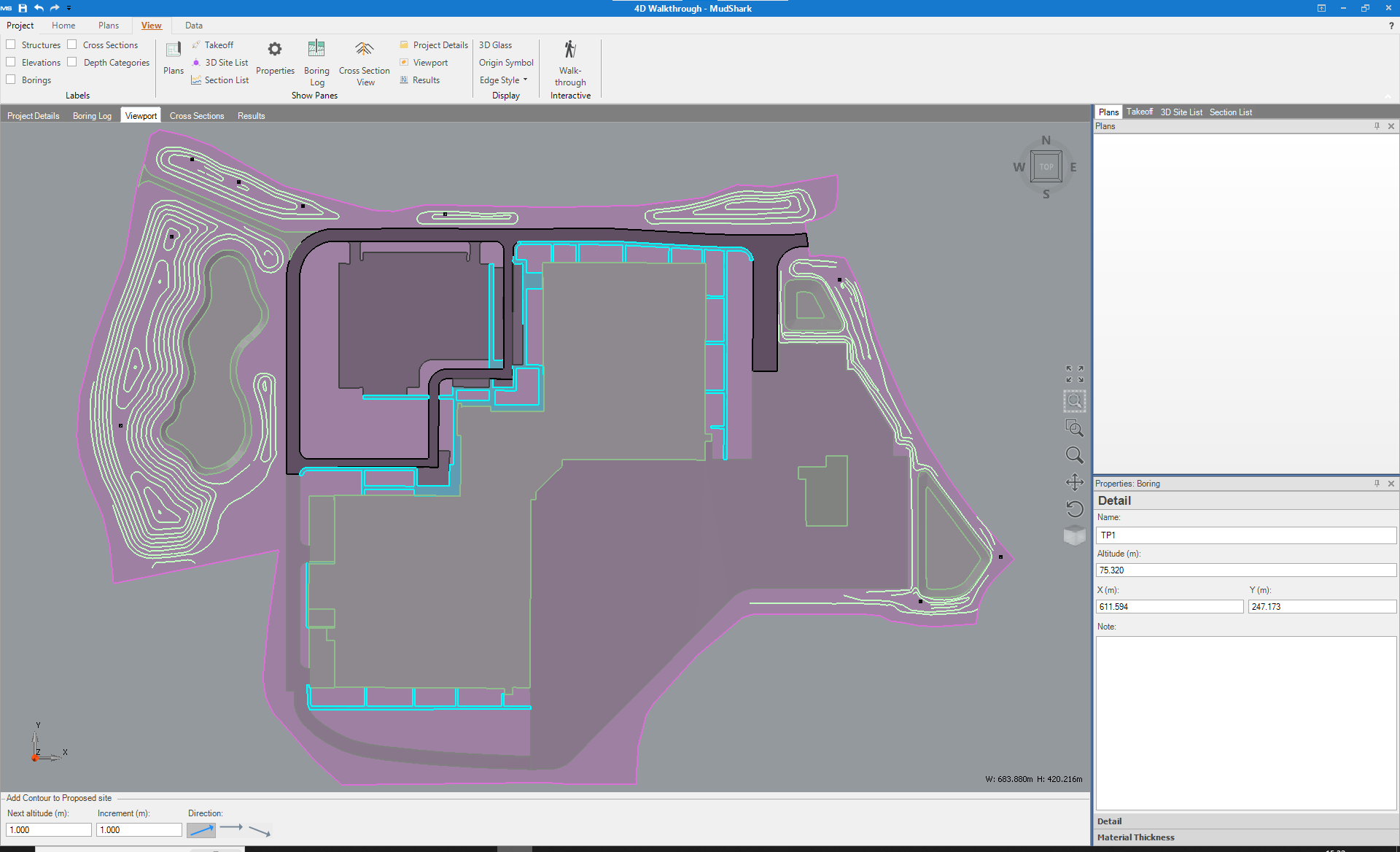
Multiple Boring
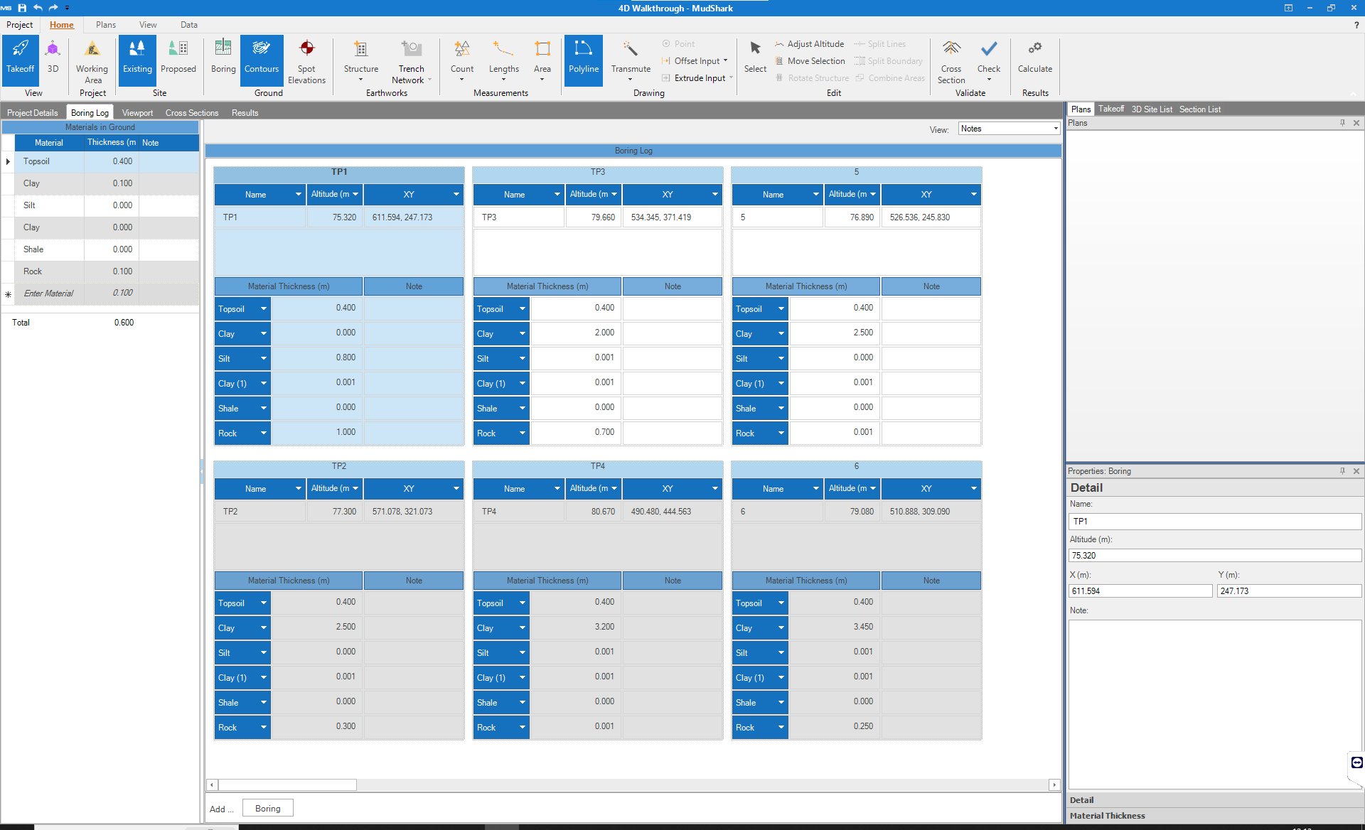
Are you calculating projects where soil or rock thickness is irregular across your site?
Your earthwork estimations will be more accurate then ever with our multiple boring solid modelling. Quickly define and plot (or plot then define) as many boring points as your site needs. Giving you precise 3D solid volumes in a fraction of the time of manual calculation.
Cross Sections

Explore your site with our fully detailed in-place 3D and 2D cross sections. Generate and print cross sections of any shape and inspect how the site changes along that cross section during cut and fill operations.
Now you can have even more confidence in the easiest and most precise way to estimate your earthworks by using Mudshark.
Material Reuse

MudShark makes it easier to to enter, manipulate and Control how materials are used in your site.
Designate which materials can be reused and where; for strata operations or for each material. Also. nominate Materials that are unfit to be used and must be discarded
More Features
| Earthworks | Trench Only | Earthworks and Trench | |
| Administration | |||
| Flexible Licensing | |
||
| Project Material Re-use | |
||
| Unlimited Projects | |
|
|
| Materials Database | |
|
|
| Information Input | |||
| Removal of demolition areas | |
||
| Sub-grade materials | |
|
|
| Existing Site Surface Definition (Contour lines, point elevations and sloping design lines) | |
||
| Surface, basement and sub-grade areas | |
|
|
| Demolished Structures (Brown fields) | |
|
|
| Boring logs and soil strata details | |
|
|
| PDF and CAD Takeoff | |
|
|
| 3D CAD objects imported directly from DWG files | |
|
|
| Plan stitching and alignment | |||
| Proposed Site Surface Definition (Contour lines, point elevations and sloping design lines) | |||
| Length and area measurements | |||
| Contour lines, point elevations and sloping design lines | |||
| Multiple working areas | |
|
|
| Verification | |||
| Clash Detection | |
|
|
| Solid model calculation | |
||
| 3D verification | |
|
|
| 4D walk through | |
|
|
| Cross Sections | |
||
| Results & Exports | |||
| Depth categories | |||
| Trench Cut accounting for structures and respread. | |
||
| Trench Fill Materials accounting for structures and respread. | |
|
|
| Trench volumes/materials | |
|
|
| Proposed Site Structures Cut and Fill | |
|
|
| Stripping and Respread | |
|
|
| Existing to Proposed cut and fill | |
|
|
| Cut & Fill Volumes | |
|
|
| Demolished structure and Built structure resutls | |
|
|
| Automatic site balancing adjustments | |
|
|
| Topsoil strip | |
|
|
| 3D Printing format | |||
| Export to excel | |||
| Export to estimating software | |||
| Re-spread areas | |||
Mudshark Earthworks FAQs
What is MudShark Trench??
MudShark Trench is a separate product to MudShark, and can be purchased as standalone software or for the best value it can be bundled together with MudShark.
Is MudShark a cloud (web-based) solution?
No, MudShark is not a cloud solution.
Our Products
Cubit Estimating Standard
Allows you to perform your quantity takeoff directly inside your estimate.
Key Features
- 2D Takeoff
- 3D Visualisation
- Templates / Price lists
- Variations Management
- and more
Cubit Estimating Pro
The power and flexibility expected from building estimating software.
Key Features
- 2D Takeoff
- BoQ Production
- Job Revisions
- Tender Analysis
- and more
Cubit Estimating Enterprise
This licence allows you to import and takeoff quantities from IFC models.
Key Features
-
IFC BIM Takeoff
-
Multiuser collaboration
-
BIM Revisions
-
BOQ Production
-
Tender analyses
Cubit Select
Innovative, online platform designed to compare suppliers and contractors.
Key Features
- Trade packages invitations
- Multiple quotes
- Document Management
- Online Bid Submission
- and more
Mudshark Eartworks
Easily and accurately performing takeoff for earthworks.
Key Features
- Rapid Takeoff
- 3D Models
- Multiple Boring
- Cross Sections
- Material Re-Use
Buildsoft Global
1000's of users working in commercial, industrial and housing sectors.
Key Features
- 4 Level Estimating
- Progress claims
- Bills of Quantities
- Variations Management
- and more
News and Insights
Buildsoft attend the CitA BIM Gathering in Croke Park
[fusion_builder_container hundred_percent="no" equal_height_columns="no" hide_on_mobile="small-visibility,medium-visibility,large-visibility" background_position="center center" background_repeat="no-repeat" fade="no" background_parallax="none" parallax_speed="0.3"...
Brightbox launches new website for MudShark
[fusion_builder_container hundred_percent="no" equal_height_columns="no" hide_on_mobile="small-visibility,medium-visibility,large-visibility" background_position="center center" background_repeat="no-repeat" fade="no" background_parallax="none" parallax_speed="0.3"...
Product Update: Cubit 7 now released
[fusion_builder_container hundred_percent="no" equal_height_columns="no" hide_on_mobile="small-visibility,medium-visibility,large-visibility" background_position="center center" background_repeat="no-repeat" fade="no" background_parallax="none" parallax_speed="0.3"...

We understand estimating construction projects can be
complex and tiring. We’re here to make it much easier.