The simple solution for companies and contractors
MudShark Earthworks
Mudshark delivers precise earthwork estimates in record time.
Mudshark is a powerful civil construction estimating tool that helps contractors, engineers, surveyors, and QSs quickly produce accurate earthwork volume calculations and visualisations. Combining intuitive 3D takeoff tools with rapid data input and advanced solid modelling, Mudshark allows users to build detailed cut-and-fill models of existing and proposed site conditions, streamlining earthworks planning and cost estimation for projects of all sizes.

What is Mudshark Earthworks?
Mudshark Earthworks provides fast and accurate earthworks estimating at your fingertips. Features include:
-
-
- Smart 3D Takeoff Tools
- Rapid Data Input
- Multiple boring solid modelling
- Fully interactive 3D visualisation
- Integrations with leading estimating solutions
- Multiple file type support (PDF, CAD, DWG, DXF)
- Configurable estimating format (metric/imperial)
- 3D cross section calculations
- Pipe network clash detection – MudShark Trench
- Pipe and trench network takeoff – MudShark Trench
-
Who is Mudshark Designed For?
MudShark Earthworks is built to support professionals who need fast, accurate and reliable earthworks takeoff and volume estimation in civil construction projects. It’s ideal for:
- Estimators looking to quickly calculate cut and fill quantities with precision
- Contractors who need efficient earthworks planning and site analysis
- Civil Engineers requiring detailed 3D visualisation and material breakdowns
- Surveyors handling complex terrain, boring data and interactive solid models
- Quantity Surveyors producing cost-effective, defensible estimates for bids and proposals
Whether you’re working on small site preparation or large, multi-layered earthworks, MudShark provides intuitive 3D takeoff tools and powerful solid modelling to help you deliver accurate results faster than traditional methods.
Testimonial:
“Finding the right tools are part of the challenge for a Quantity Surveyor and MudShark fitted this role perfectly.
MudShark fulfilled the need to provide technical data in the form of quantities in a fast and efficient manner. Its simplistic methods of obtaining accurate quantities enhance our roles as industry leading construction cost consultants to our valued clients.”
Contact Us
Simply fill out your details
and we will be in touch!
Webinars

INTRODUCTION TO MUDSHARK
This Webinar demonstrates the main features in MudShark.
Thursday 11:00am GMT (30 mins)
Experience the benefits for yourself with a free trial.
Get Started With a Free Trial
Mudshark Earthworks Estimation Features:
Rapid Takeoff
Using data in a PDF/CAD file can reduce take off time to a fraction of what it would traditionally be. Pick the lines that you want to use as Contours and if you’ve inserted a 3D CAD file you can transmute all of your contours in seconds using the altitudes already set in the Plan.
Depth Categories

MudShark has a Depth Categories feature which allows you to generate a map of your site separated by Depth Range.
Depth Range values are determined by what Profile is selected. By default the 3 most used formats are defined: ARM4, NRM2 and SMM7. You can configure your own Depth Category Profiles if required.
If you are unfamiliar with the term “Depth Category”, imagine a heatmap where you are separating areas based on predefined values e.g.
Depth Range one: 0m – 2m
Depth Range two: 0m – 4m
Depth Range three: 0m – 4+m
Multiple Boring
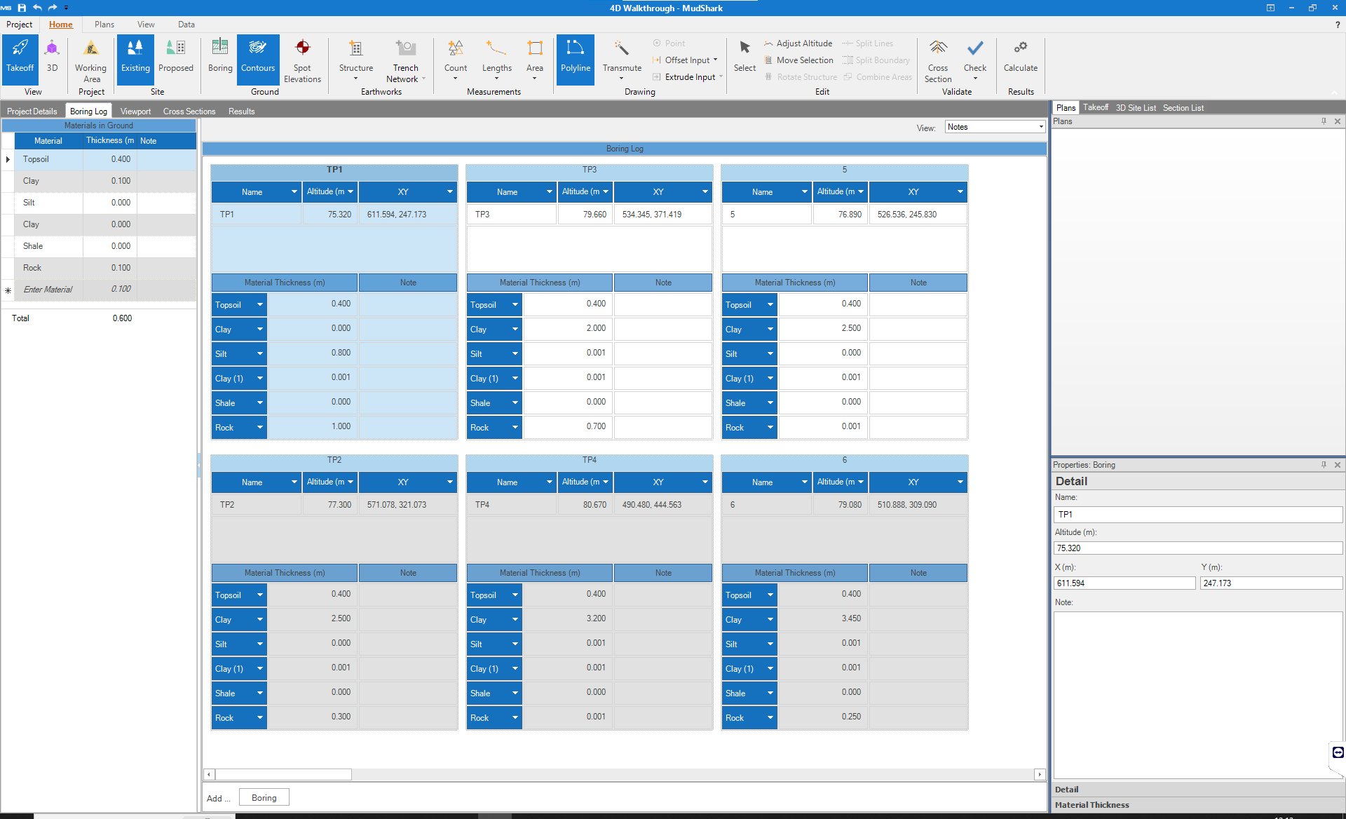
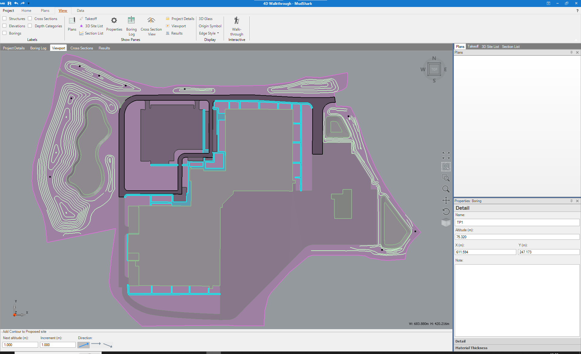
Are you calculating projects where soil or rock thickness is irregular across your site?
Your earthwork estimations will be more accurate then ever with our multiple boring solid modelling. Quickly define and plot (or plot then define) as many boring points as your site needs. Giving you precise 3D solid volumes in a fraction of the time of manual calculation.
Cross Sections

Explore your site with our fully detailed in-place 3D and 2D cross sections. Generate and print cross sections of any shape and inspect how the site changes along that cross section during cut and fill operations.
Now you can have even more confidence in the easiest and most precise way to estimate your earthworks by using Mudshark.
Material Reuse

MudShark makes it easier to to enter, manipulate and Control how materials are used in your site.
Designate which materials can be reused and where; for strata operations or for each material. Also. nominate Materials that are unfit to be used and must be discarded
More Features
| Earthworks | Trench Only | Earthworks and Trench | |
| Administration | |||
| Flexible Licensing | |
||
| Project Material Re-use | |
||
| Unlimited Projects | |
|
|
| Materials Database | |
|
|
| Information Input | |||
| Removal of demolition areas | |
||
| Sub-grade materials | |
|
|
| Existing Site Surface Definition (Contour lines, point elevations and sloping design lines) | |
||
| Surface, basement and sub-grade areas | |
|
|
| Demolished Structures (Brown fields) | |
|
|
| Boring logs and soil strata details | |
|
|
| PDF and CAD Takeoff | |
|
|
| 3D CAD objects imported directly from DWG files | |
|
|
| Plan stitching and alignment | |||
| Proposed Site Surface Definition (Contour lines, point elevations and sloping design lines) | |||
| Length and area measurements | |||
| Contour lines, point elevations and sloping design lines | |||
| Multiple working areas | |
|
|
| Verification | |||
| Clash Detection | |
|
|
| Solid model calculation | |
||
| 3D verification | |
|
|
| 4D walk through | |
|
|
| Cross Sections | |
||
| Results & Exports | |||
| Depth categories | |||
| Trench Cut accounting for structures and respread. | |
||
| Trench Fill Materials accounting for structures and respread. | |
|
|
| Trench volumes/materials | |
|
|
| Proposed Site Structures Cut and Fill | |
|
|
| Stripping and Respread | |
|
|
| Existing to Proposed cut and fill | |
|
|
| Cut & Fill Volumes | |
|
|
| Demolished structure and Built structure resutls | |
|
|
| Automatic site balancing adjustments | |
|
|
| Topsoil strip | |
|
|
| 3D Printing format | |||
| Export to excel | |||
| Export to estimating software | |||
| Re-spread areas | |||
Key Features of Mudshark Earthworks:
Smart 3D Takeoff Tools
Interactive 3D takeoff and solid modelling tools make calculating cut and fill fast, visual and accurate.
Depth Categories & Cross Sections
Generate detailed depth maps and 2D/3D cross sections to analyse how the site changes across cut/fill operations.
Rapid Data Input & Multiple File Support
Quickly import site plans and data from PDFs, CAD, DWG or DXF files to jumpstart takeoff work.
Material Reuse Management
Define which materials can be reused or must be discarded, helping with material planning and cost efficiency.
Multiple Boring Solid Modelling
Account for varied soil or rock depths across a site for more precise volume estimates.
Trench & Pipe Network Takeoff (Integration with MudShark Trench)
Includes trench and pipe network tools with clash detection for utilities and drainage systems when paired with the Trench module.
Experience the benefits for yourself with a free trial.
Get Started With a Free Trial
Mudshark Earthworks FAQs
Yes, Mudshark allows users to import site plans and data from PDFs, CAD, DWG, or DXF files to facilitate takeoff work and improve accuracy.
Mudshark is a civil construction estimating tool that provides quick, accurate earthwork volume calculations and visualisations, helping contractors and engineers streamline earthworks planning and cost estimation.
Earthwork estimation involves calculating the volume of soil or rock to be excavated or filled during construction projects, essential for cost planning and resource management.
Mudshark enables users to designate materials for reuse or discard, helping with material planning, cost efficiency, and controlling how materials are used during site operations.
Accurate earthwork estimation helps prevent cost overruns, optimize resource allocation, and improve project scheduling, leading to more efficient construction management.
Common tools include civil construction estimating software like Mudshark, CAD and PDF import features, 3D takeoff tools, and solid modeling techniques to improve accuracy and efficiency.
Our Products
Cubit Estimating Standard
Allows you to perform your quantity takeoff directly inside your estimate.
Key Features
- 2D Takeoff
- 3D Visualisation
- Templates / Price lists
- Variations Management
- and more
Cubit Estimating Pro
The power and flexibility expected from building estimating software.
Key Features
- 2D Takeoff
- BoQ Production
- Job Revisions
- Tender Analysis
- and more
Cubit Estimating Enterprise
This licence allows you to import and takeoff quantities from IFC models.
Key Features
-
IFC BIM Takeoff
-
Multiuser collaboration
-
BIM Revisions
-
BOQ Production
-
Tender analyses
Cubit Select
Innovative, online platform designed to compare suppliers and contractors.
Key Features
- Trade packages invitations
- Multiple quotes
- Document Management
- Online Bid Submission
- and more
Mudshark Eartworks
Easily and accurately performing takeoff for earthworks.
Key Features
- Rapid Takeoff
- 3D Models
- Multiple Boring
- Cross Sections
- Material Re-Use
Buildsoft Global
1000's of users working in commercial, industrial and housing sectors.
Key Features
- 4 Level Estimating
- Progress claims
- Bills of Quantities
- Variations Management
- and more
News and Insights
Cubit and MudShark Training Quarter 2 – 2026
See below our training dates for quarter 2 of 2026. These courses may be used towards CPD hours. If you have any questions or would like to book a date, please contact stephen@bsssoftware.com. More details can be found...
What is the carbon footprint of a building?
The carbon footprint of a building refers to the total amount of greenhouse gas emissions produced throughout its lifecycle. This includes emissions from construction, operation, maintenance, and the eventual demolition or disposal. Buildings contribute significantly...
The benefits of cloud hosted estimating software
Construction estimating software is widely recognised for the advantages it delivers to construction professionals across the globe. From lowering costs and improving operational efficiency to supporting collaboration and more accurate profit forecasting, adopting...

We understand estimating construction projects can be
complex and tiring. We’re here to make it much easier.